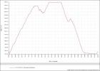
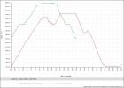
After my hikes on my GSNM phototrip in may/june this was my first long home hike in 2011. Like every year I hike the Herzogstand to Heimgarten rim loop starting in Urfeld. A total of 20km (12.5 miles) and a summed elevation difference of 1376 m (4500 feet) in climbing.This year it took me 2h from Urfeld to Herzogstand peak, 1h on the rim from Herzogstand to Heimgarten 2 hours down to Walchensee village and finally another hour back along the Walchensee lake back to the car park. This time I had exactly tracked the Hike on the GPS to compare it with one of the more strenous hikes in USA, the Observation point hike. Doing those hikes in US I never could really rank how difficult they were. The Observation point hike in Zion N.P. was with 4h quite short but the one I had the most elevation difference. I was surprised when comparing the GPX tracks that the summed height difference there was only 780 meter (2560 feet).. In both hikes my pace was quite high being in good shape this year. Hope this gpx and screen logs will motivate me in the coming years to keep the pace and shape.
here my 2011 GPX track of the Herzogstand-Heimgarten loop hike


